If you’ve ever wondered what was previously on the site of your house, or wanted to find out where your ancestors lived, then historic Ordnance Survey (OS) maps are often a good place to start.
Thanks to the freely available maps of England & Wales on the National Library of Scotland (NLS) website, it’s now possible to see some of the old OS maps overlaid onto a modern satellite image, making it much easier to get your bearings.
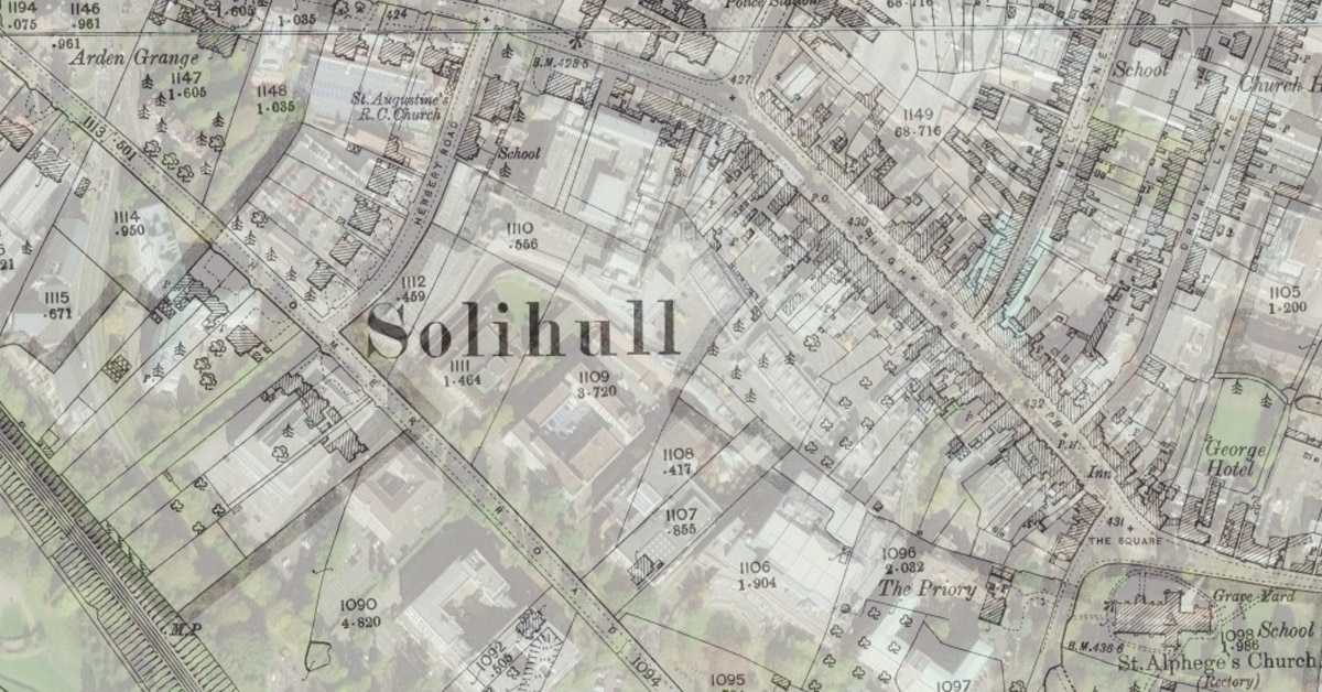
All librarians, archivists and researchers know that it seems to be a rule that the area someone wants to find out about is almost always on the edge of two maps, if not four. With digitised and georeferenced maps, this is no longer a problem and the NLS site allows you to move around an area seamlessly, whether as an overlaid image (as at the top of this page) or side-by-side image (as below). If your images are overlaid, just drag the blue dot you see on the screen to change the transparency of the map image to see the satellite image below.

The NLS site includes the second edition 25-inch and 6-inch OS county series maps, dating from around 1902 for the Solihull area. If you look at the bottom right of the screen, you should see the number and date of the map. Knowing the sheet number may help you to identify what other sheets are available on the site, as there are additional maps that are viewable as individual sheets rather than as the zoomable overlay layers.
To view individual maps – see the list by county (Solihull is listed under Warwickshire) or the graphical list where you enter the place name you are looking for and can then see a grid of where the sheet boundaries area. Once you select the part of the grid you are interested in, you will see a list of available maps on the right of the screen.
If you can’t find the map you are looking for, the Core Library, Solihull does have 25-inch (1:2500) or 50-inch (1:1250) paper OS maps for all areas in the present Borough of Solihull from the first edition (late 1880s) to the present day.
The first edition local OS maps are available free of charge as PDFs downloadable via our online catalogue entry – just click on the relevant area link to go to the map entry and then open the PDF by double-clicking on the CD icon. We are aiming to add the other county series maps to our catalogue in due course, but if there is a map you’re interested in, please email heritage@solihull.gov.uk and we’ll do our best to help (copyright permitting, of course).
Tracey
Heritage & Local Studies Librarian

I am trying to find out if there was a POW camp for Italians in the 1940s at the Robin Hood Golf Course. My dad was stationed in Solihull during that time and we can’t find out anything about it. I wondered if it would show up on a map of the 1940s.
Chris Rhodes
Unfortunately, the OS maps were produced at about 20-year intervals so we have maps for 1937 and then nothing until the 1950s, so there wasn’t a survey at the relevant date. I’ll see if we have anything else that would help, and will let you know.
Tracey
Thank you. Chris
https://archivesunlocked.warwickshire.gov.uk/CalmView/TreeBrowse.aspx?src=CalmView.Catalog&field=RefNo&key=01404%2f2%2f10%2f2%2f1
Looking for location on a recent map. Especially Ansett Field. Kind regards Tony Ansett Lara Victoria Australia
The catalogue entry suggests that Ansett Field and the other places listed are actually situated in Aldridge rather than Solihull so it would be worth emailing Walsall Archives in case they are able to help: LocalHistoryCentre@walsall.gov.uk