
If you are interested in tracing the history of a house or building, the starting point should be the building itself or a picture of it if it no longer exists, and any anecdotal information/existing research. The crucial information you need in order to search most effectively is the approximate date of construction, as this will help you to identify what records may be available and where they may be.
When was the property built?
The construction materials and styles should give you some clues as to the approximate construction date. You should try to determine in which century it was built, and then try to narrow the date to within a few decades or years, if possible. It will be much easier to identify relevant records if you know whether your house was built in the 1920s or the 1820s, for example.
If you’re lucky, the building may have a plaque or carving identifying the year it was built, and sometimes including the original name or the owner’s initials. It’s worthwhile trying to confirm the information from other records, especially if the date plaque or stone was added some time after construction rather than contemporaneously.
- The University of Western England has a useful guide to domestic architecture styles 1700-1960 and a guide to structural elements such as walls, foundations, roofs and windows.
- The Georgian Group has produced a guide to brickwork that may help to date a property using the style of brick and the horizontal pattern (bond) in which the bricks are laid.
Finding property deeds
Title deeds show the chain of property ownership so may give you the dates when the house was built and the names of the original and subsequent owners. They can include conveyances, contracts for sale, mortgages, Wills and leases.
The deeds are usually held by the owner of the property so, if there is a mortgage, the mortgage lender is likely to have custody of the deeds. If so, you may need to pay a fee to access them.
The Land Registry does not store paper title deeds. Generally, it receives the deeds when a property is registered for the first time, scans a copy of the deeds in order to prepare the register entry, and then returns the deeds to the sender. The sender may be a solicitor or mortgage lender.
To find out if the Land Registry has title deeds for a property, you need to search the property register and see if the entry refers to title deeds as being filed. If so, you should be able to obtain a digital copy for a small fee.
- Land Registry – search the register and obtain a copy of title deeds
Under the Law of Property Act 1925 there was no requirement to hold evidence of title for more than 30 years (now 15 years) so it is possible that older deeds have been destroyed. Sometimes they may be in archive collections, so it’s worth searching the catalogues of relevant archives or local studies libraries.
Online catalogues
Historical deeds may be held by the local record office or local studies library for the county or district in which the property is or was situated. They may have been lodged there by individual owners or be amongst the archives of solicitors’ papers that have been deposited.
You may be able to find a sale catalogue, notably for larger houses or estates, especially for the 19th- and early-20th centuries.
For the Solihull area it’s worth trying the following online catalogues:
- Solihull Heritage Gateway (Solihull Libraries Heritage & Local Studies Service)
- Warwickshire’s Past Unlocked (Warwickshire County Record Office)
- Birmingham Archives and Heritage Catalogue
- Worcestershire Archives and Archaeology – Explore the Past Archive Catalogue
- Birmingham Archdiocesan Archives (for Roman Catholic records)
For other archive services, check The National Archives’ Find An Archive list to locate the relevant record office and check for a link to their online catalogue.
When searching the catalogues, try searching for the name of the property (if it has one) or just the road. It’s worth bearing in mind that road names may have changed over the years, so checking for any previous names may be useful. If you don’t have any luck with the road name, broaden your search to the wider area.
Historic England holds the Aerofilms archive of aerial photographs, many of which are available on their Aerial Photo Explorer website: https://historicengland.org.uk/images-books/archive/collections/aerial-photos/
Understanding Title Deeds
Bundles of deeds can be daunting but they are an essential resource for researching the history of land and property. If the bundle contains one or more Abstracts of Title, for example, this can be a useful summary of the property’s history, and may refer to deeds that are not included in the surviving bundle.
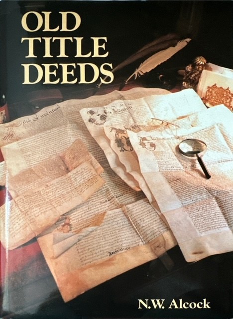
- The book Old Title Deeds by N. W. Alcock gives a comprehensive explanation of different types of deeds and how they can be useful for local and family history research. Copies are available at Solihull Libraries.
- The University of Nottingham has an online guide explaining about deeds
Is the property listed?
Historic England maintains the National Heritage List for England, which is the official register of protected buildings, scheduled monuments, protected wrecks, registered parks and gardens, and battlefields. You can search the list or browse by place.
Local authorities also keep a Local List of Heritage Assets which includes buildings that are important locally but that do not meet the criteria for national listing. See Solihull Council’s website for Solihull’s Local List.
The formal concept of Conservation Areas was introduced by the Civic Amenities Act 1967. Solihull’s first two Conservation Areas – the respective centres of Solihull and Knowle – were designated on 28th June 1968. There are now 20 Conservation Areas in the Solihull Borough.
Location, location, location!
You may know where the property is now, but boundary changes can affect the location of records. Try to find out the electoral ward(s) in which the property has been situated, as well as the parish and county. Useful sources for this are:
- Ordnance Survey maps – many of these maps 1880s-c.1970 (including places in the Solihull Borough) are now freely available online at the National Library of Scotland website. See our previous guide for further details of how to access these.
- Tithe maps – these were produced around the 1840s and the accompanying tithe apportionment gives details of the land owner, occupier and a description of the property. The Who Do You Think You Are? website has an article about tithe maps and their usefulness.
The Core Library has copies of tithe maps for most parishes in the Borough. However, the easiest way of looking at the tithe map is via The Genealogist website, which is accessible free of charge from library computers (or from home, if you have a personal subscription). There’s a video here on how to use the Map Explorer on the site: https://www.thegenealogist.co.uk/help/video-tutorials
It’s also worth knowing if the property had a name, and also whether this name changed over time. Addresses as we know them are a relatively recent way of identifying a property. In small settlements particularly, the name of a property and the name of the village were sufficient means of identification.
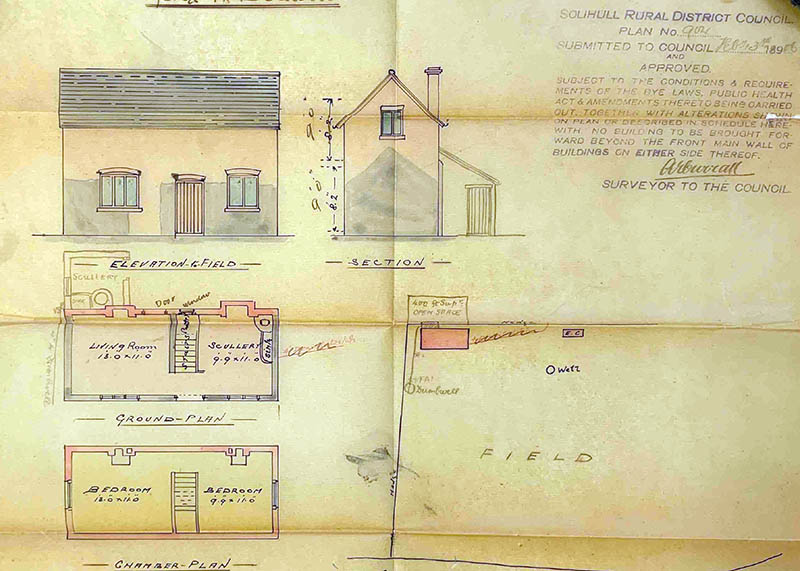
Building plans
If your property is in the former Solihull Rural District area and was built between 1880-1932, the original building control plan may have survived and be in the Council’s archives at The Core Library.
Unfortunately, most of the plans we hold do not include house numbers – they mostly just give the road name. However, if you have information (e.g. from the deeds) about the original owner and the date of construction, you may be able to narrow down the possible plans using this information.
Search our online catalogue to find the plan reference and then email heritage@solihull.gov.uk if you want us to email a copy to you or if you want to arrange an appointment to view the plan.
Unfortunately, we don’t hold building plans for places that came into the Solihull Metropolitan Borough in 1974 and were previously in the Meriden Rural District. Pre-1974 building control plans for places in the Meriden Rural District are held at Warwickshire County Record Office.
Newspapers
Old newspapers can be extremely useful in finding out about the history of a building, particularly for house sales and for the building of new estates. The British Newspaper Archive website is available free of charge in all Solihull Libraries (although you will need to set up your own free account to access it). It has searchable local newspapers from all regions of the UK and some overseas titles, which can lead you to interesting stories or hidden histories not documented elsewhere.
We have produced a step-by-step guide to registering for the site – it’s a good idea to do this from home if you can, as you can then search for items of interest, bookmark them, and then view them quickly when you visit the library and can access the full articles. We also have a guide with tips on searching the site more effectively.
Local history and context
It’s worth looking at the building in the context of the local area as the local history may give you some useful clues. For example, if your property was part of a landed estate, you may be able to find information through sale catalogues or plans of the estate. Perhaps a large employer relocated to the area, which resulted in a population increase and the need for more housing.
Most large libraries have a local history collection, which is likely to include books, pamphlets, maps and photographs. The collection may be held at the same place as the archives, for example in a combined history centre. It’s worth searching the general catalogue of the library service that covers the area where your property is situated.
Local history groups may have very knowledgeable members who may have researched the area you are interested in. The British Association for Local History (BALH) keeps a list of local history societies in Britain.
Talking to neighbours or people who have lived in the area for a long time can yield interesting stories about the property and its owners, although these may need to be corroborated from other sources!
Council housing
If the property was built on behalf of the local authority, especially as part of a housing estate, then there may be information in Council minutes (which may also have been reported in newspapers at the time).
Council housing in Solihull is now managed by Solihull Community Housing who may be able to help with dates of construction of particular properties.
It may be difficult to track down relevant documents, particularly in the early stages of development when roads may not have been named, so it is worth looking at the local history context and seeing what was on the site before the roads were constructed. For example, if a large farm was subsequently developed for housing, it may be that the name of the farm was used at the beginning of the development so it would be worth searching newspapers etc. for the farm as well as the names of the roads.
Council minutes could also be a useful source of information about the construction of roads and estates although it may be easier to use articles in newspapers to find the relevant Council committee date first as most Council minutes do not have comprehensive indexes.
Solihull Council maintains a “List of Streets” in the Borough with an indication as to whether the road has been adopted by the local authority and is therefore publicly maintained and managed. Where the road has been adopted by the Council, the date of adoption may indicate an approximate construction date.
The Core Library holds the Highways Register for Solihull (ref. SOL/TS/3/2) which gives details of the adoption dates and lengths of roads adopted and sometimes gives additional information about the dates of any changes of name of the road.
The Highways Register only covers roads adopted before 1998. It does not appear to include those streets that were in Meriden Rural District prior to 1974. If you wish to view the Highways Register, please make an appointment with us at least three working days’ in advance of your intended visit.
Tracing occupants
Other sources that can be useful are electoral registers 1832 to date, although for the Solihull district these are in surname order before about 1930 rather than by address, so it can be difficult to trace a particular property.
Electoral registers only list people entitled to vote so won’t include, for example, any children, or any women before 1918 (apart from a few women who may have been entitled to vote in local elections). For Solihull, there are copies of electoral registers from 1832 at The Core Library – please email heritage@solihull.gov.uk for further details and to make an appointment to view these.
Census records are available 1841-1921 from library computers but, again, these are more easily searched by name than address, as the addresses on censuses are often not recorded as precisely as we would do now – e.g. house numbers are often not included and sometimes road names are omitted as well so it’s not uncommon, for example, for an address to be listed as “village.”
At the beginning of each group of census entries 1841-1901 there is a page where the census enumerator described the geographical area whose residents were enumerated on the following pages. It can be helpful to look at this description and compare it with a contemporary map as this can help to identify properties where the census address is not clear.
All of our libraries in Solihull offer free access from library computers (or from your own laptop/tablet device connected to the free Solihull Libraries Wi-Fi) to the Ancestry and Find My Past websites. If you need any further information about accessing the sites from the library, please email heritage@solihull.gov.uk
Trade directories were compiled mostly to aid commercial travellers and these can give details of residents as well as listing facilities available and including classified directories by trade. They were published from the early 19th century on a county by county basis and towns and villages are listed alphabetically. The last county directory published for Warwickshire (including Solihull) was 1940.
Directories can be helpful if the occupier was a well-to-do resident or a tradesperson working from the address. However, it’s not uncommon for trade directories just to list the road (and/or house name) rather than specifying a particular house number.
Some directories of cities or large towns do include street listings, which give the name of the head of the household at each address and are arranged alphabetically by street. For Solihull, the Core Library only has such listings from 1961 and 1962 as the county directories do not include a street listing.
In 1939 a National Register of the population was compiled, listing all civilian residents at each address in England & Wales on 29th September 1939. This was used to produce ration books and identity cards and went on to form the basis of the NHS Register in 1948. The National Register is available on the Find My Past and Ancestry websites (accessible free of charge from computers at all Solihull Libraries). Further information about what the register includes is available on the National Archives website.
Other sources available at The National Archives
The Valuation Office Survey 1910-15 took place as a result of the Finance Act 1909-10. “Domesday Books” were produced at the start of the survey with plans (maps) indicating reference numbers that correspond to the Field Books that usually include the names of the owner and occupier and details of the property. Sometimes the date of the erection of buildings is included.
A National Farm Survey of England & Wales was carried out in 1941-43, so this may be of interest if you are researching the history of a farm. Records are held at The National Archives and there is a research guide available.
If you have any queries about properties in the present Solihull Borough or former Solihull Rural District, please email heritage@solihull.gov.uk and we’ll do our best to help. Staff are unable to undertake in-depth research but we can check individual records and advise on sources that may be relevant to your search.
Tracey
Library Specialist: Heritage & Local Studies
The Core Library, Solihull

Leave a comment